Nov. 3-4, 1927, the State of Vermont was visited by a drastic flood. In late 1927, “Floodtide of 1927” was published. Below is the Springfield section.
From the introduction
“Nature never smiled more kindly on good little old Vermont than she did during the autumn of 1927. The outdoors was glorious….
…With but two or three frosts coming late in October, and only one of these a killing freeze, the harvest season, favored by plenty of clear weather, was long and propitious…The barns, silos, storehouses and cellars of the hard-working Vermont farmer were full of products of the field and orchard…
…During the evening of Wednesday, November 2d, a warm rain began to fall…It appeared like a mere shower – the more so as, almost from the start, it rained hard. When morning came, the rain continued right along without diminution in volume…Hour after hour the rain fell without slackening or giving any sign that it was about over…
And then word spread that the streams were very high and rising fast—higher than in ‘25…The familiar brooklet or river, leaving its usual low channel, had swollen in angry flood…If there was a dam or protecting wall in its way it pounded with the force of ten thousand demons at it, crying, “Let me through, let me through!”…
…And still the rain fell as hard as before, feeding these already gorged streams with ever-growing flood force. Would it never stop?”
Springfield
“With the waters in the Black River abated, Springfield faced a heavy property loss. Factories inundated, houses swept away, bridges carried out, streets and highways gullied, and stores submerged was the story.
Although practically all of Springfield’s industrial plants suffered some damage, the Fellows Gear Shaper [100 River Street] and Vermont Snathe Company [near Edgar May Center] experienced the heaviest losses.
The first floor of the Fellows Gear Shaper factory was submerged to a depth of eight feet and receding waters Saturday left a badly damaged, mud-caked plant. Two corner walls of the Vermont Snathe Company’s plant were washed away by the high water which did damage in other sections of the buildings.
Six houses were swept away by the swift current and many more were damaged. Families were taken from flooded homes in boats.
The water swept through the business section of the town, flooding at least seven of the principal retail establishments on main street.
Water washed across the Main street in several places. Clinton street was under water to a depth of eight feet and a new stretch of macadam laid last year was gutted and carried away.
The large iron bridge over the Black River near the plant of the Vermont Snathe Company went out Saturday and the lower Clinton Street Bridge was wrecked beyond repair. A dozen smaller bridges within the confines of the town were carried away.
All highways out of Springfield, with the exception of the road to Chester, were blocked by heavy washouts or submerged under several feet of water and the town was without outside communication until late Saturday night.
The Springfield Terminal Railway was a heavy loser. The flume at the power house near Gould’s Mills, as well as the gate at the dam, were swept away by the flood, and heavy damage was done to the track when the waters, breaking through after the gate had gone, gullied out the highway and roadbed for a distance of more than a 100 yards near the power house, leaving the rails suspended in the air.
The same condition existed at Seaver’s brook, where the river broke through the retaining wall and completely swept away the highway for a distance of nearly 100 yards. The tracks at Middle Switch [near the Paddock], below Gould’s Mills, also were washed away with a goodly portion of the roadbed. Water stood 20 feet deep over Middle Switch at dark Friday night.”
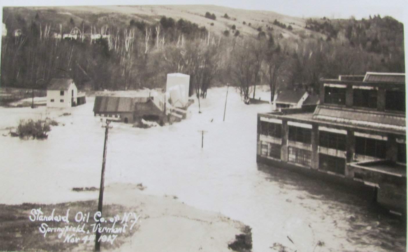
The photo
I asked Hugh Putnam of Springfield Art and Historical Society to describe the photo with this article.
“This picture was taken from somewhere on Hartness Avenue. The building on the right is the foundry building where the Springfield Fire Station is today. The Black River is on the far side of the foundry building. The oil tank and buildings are the Standard Oil Company near where HB Energy is today. You are looking down the Black River behind J&L. The water in the foreground is all floodwater. Bridge Street goes in front of the Oil Company. Two bridges are hidden by the foundry building, one a railroad bridge to the foundry, the other going to Bridge Street. This bridge was destroyed by the flood.”
Vermont Lt. Governor Hollister Jackson lost his life in this flood.
This week’s old saying: “He can resist anything except temptation.”